|
<< Click to display Table of content >> Import OpenStreetMap data |
  
|
|
<< Click to display Table of content >> Import OpenStreetMap data |
  
|
The OpenStreetMap function of MithraSIG allows to download data from internet on a specified area, and convert them automatically into MithraSIG objects. So, no need to use the process integration/convertion of data.
Warning: OSM data is open source and is not the property of Geomod. Geomod cannot be held liable of the data. It remains to the user to verify the data used for his project.
Import data
Before to use the automatic integration, it's necessary to add a backdrop, then zoom in on the area to import. The maximum extents allowed is one fifth of a degree in longitude and latitude. Note that the OpenStreetMap server may also impose other load-based limits. When the area is too large, a message appears.
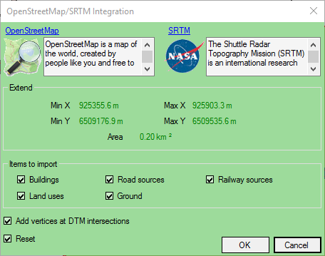
To import, from the ribbon Model, click on the button  in the group Integration. Then in the drop down menu, select OSM Integration. The import window appears.

Interface to import Open Street Map data
The window is composed of:
•Extend: X,Y coordinates min and max of the area. Coordinates are linked to the current projection.
•Items to import: select the type of items to import and integrate in MithraSIG.
•Add vertices at DTM intersections: option highly recommanded when using 2D data. For more details, read this chapter.
•Reset: check this option to reset the project and perform a new integration.
For more details about the OpenStreetMap data, follow this link.
For more details about the NASA SRTM, follow this link.