|
<< Click to display Table of content >> Integration of building |
  
|
|
<< Click to display Table of content >> Integration of building |
|
The buildings that are integrated must correspond to closed line or polygon objects.
To integrate buildings:
•From the ribbon Model, click on the button ![]() in the group Integration.
in the group Integration.

Integration of buildings
•Click the Building button.
•Select Input data by clicking on the button:
oEither 2D data for 2D surfaces.
oOr 3D data for 3D surfaces or polygons.
•Select the Overlay containing the data from the list.
•The Rounded coordinates option allows you to round coordinates of all polygon vertices.
•The Keep original attributes option allows attributes to kept on the objects in the original overlay.
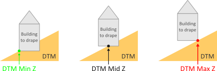
•Select a Building base computed from:
•Select an option for the Simulation of the height (see below for 2D data) from the following options:
oHeight, to use the attribute containing the height of the buildings.
oZ of the roof, to obtain the elevation of the roof.
oNum. of Floors, to use the attribute containing the number of floors.
For a building entirely in TIN type 3D, there is no need to calculate its height.
•Configuring the Nature of buildings:
MithraSIG makes it possible to configure the nature of buildings. Several types of buildings are defined in the software's library (housing, hospital/clinics, educational building, etc.). In addition, these building types can be grouped by the user into two categories:
▪'Sensitive' buildings: housing, health, educational buildings.
▪'Non-sensitive' buildings: housing, industrial or agricultural buildings, administrative buildings, offices, other buildings.
oEnter the Attribute containing the nature of the buildings in the list.
oClick on the button ![]() to set the nature parameters.
to set the nature parameters.
oIn the Corresponding values interface, enter the value of the attribute to be used for each type. It is now possible to create a match between the MithraSIG building codes and the attribute values of the selected overlay.

Configuring the Nature of buildings
Note: Without using the Nature of the buildings, the default value is Individual housing. That means all buildings will be considered as housing. During the integration process, the default value can be changed by clicking on the button ![]() on the top right hand corner.
on the top right hand corner.
The facade and roof materials are those of the default values. Their characteristics are defined and can be configured in the materials interface.
The Reset option deletes all old buildings that are already present. By leaving this option unchecked, it is then possible to add buildings to the existing 'Building' overlay. It is then possible to carry out several successive integrations in different geographical zones.
When the buildings are integrated into the project, a 'Building' overlay is added to the composition, corresponding to the 'CompositionName_Building.bds' file created and saved in the project directory. It contains buildings (polygons) draped on the project DTM as well a thematic 'Extrusion' allowing buildings to be viewed in 3D.
MithraSIG has many helpful features to simplify the integration of data and provide information on errors made by the user:
![]()
Altitudes and heights
In the first phase MithraSIG determines the elevation of the base of the building.
Next, in order to determine the height and information on the floors, there are several options: 3D data, 2D data - height, 2D data - roof elevation or 2D data - number of floors.
Note: At the end of the integration, a message appears if there are buildings that could not be draped: they are then at an elevation of -999.0 m and must be corrected by the user.
If there have been problems (missing or inconsistent attributes), an XML error file opens automatically and show a list of errors classified by type. The incorrect origin building is identified either by its object identifier or by the coordinates of its first point (if the origin data set has been inserted and is not modifiable).