|
<< Click to display Table of content >> The Land use |
  
|
|
<< Click to display Table of content >> The Land use |
  
|
MithraSIG identifies three groups of land use that can influence a simulation due to their different acoustic characteristics:
•Water areas.
•Vegetation areas.
•Urban areas.
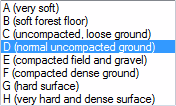
Each type of land use is then associated with a material. These materials are defined in the materials interface and their default values in the default parameters. The material options for each type of area are:

The types of land use make it possible to visually differentiate the zones defined by the materials. This differentiation of zones does not influence the simulations, only the material counts.

This data is usually supplied in the form of sets of data made up of polygons in either 2D or 3D.
If the polygons are in 2D MithraSIG projects the data onto the DTM in order to obtain the limits in 3D that will then be used during the simulation of the intersections of the propagation rays with the surrounding landscape.
If the polygons are in 3D MithraSIG uses them just as they are in the simulation of the intersections of the ray propagations with the surrounding landscape.