|
<< Click to display Table of content >> Vertical map sections |
  
|
|
<< Click to display Table of content >> Vertical map sections |
|
To visualize a vertical map section, select one or several items of the vertical map (grid, points, isovalues, polygons), then right-click and activate the command Vertical map section.
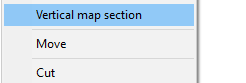
Additionally, vertical cross section can be displayed using the right-click on the map overlay.
The map displayed in section depends on the type of the selected item.
 Vertical map with receivers |
 Vertical map with grid |
 Vertical map with isovalues |
 Vertical map with polygons |
A move of the mouse on a graphic item updates the value. The unit is the one of the map.
The window is sizable by clicking on the button ![]() , to have several options to manage X/Y scale, display text / scale .axis, and to save the cross section as an image.
, to have several options to manage X/Y scale, display text / scale .axis, and to save the cross section as an image.