|
<< Click to display Table of content >> Map parameters |
  
|
|
<< Click to display Table of content >> Map parameters |
|
These parameters are used by default when a new map is created.
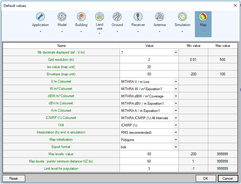
•Number of decimals displayed: number of decimals that can be visualized in V / m when creating maps.
•Grid resolution: resolution offered when a grid type map is created.
•Isovalues: default isovalues when an Isovalue or Polygon type map is created. If there are several values they are separated by a ';'.
•Envelope: default isovalue when creating an envelope map.
•V/m colour set: default color set when the map unit is V/m when creating a map.
•W/m ² colour set: default color set when the map unit is W/m ² when creating a map.
•dBW/m ² colour set: default color set when the map unit is dBW/m ² when creating a map.
•dBV/m colour set: default color set when the map unit is dBV/m when creating a map.
•A/m colour set: default color set when the map unit is A/m when creating a map.
•ICNIRP (%) colour set: default color set when the map unit is ICNIRP (%) when creating a map.
•Unit: use for the map and antennas contributions.
•Interpolation (Vt and hz domain): interpolation method of a point in a face / segment. RMS (Root Mean Square) interpolation = interpolation on (V/m)², linear interpolation = interpolation on V/m.
•Map initialization: indicate the default type of map.
•Export format: format of the exported file. Possible formats are (.bds is editable):
![]()
•Niveaux max : valeur : valeur par défaut du filtrage des niveaux maximums sur une carte.
•Max levels: points' minimum distance HZ (m): minimum horizontal distance between two neighboring hot points when computing maximum levels. This parameter applies only for constant height domains and allows to limit the number of hot points.
•Limit level for population: limit value used in population per interval (-1 = ignored).