|
<< Click to display Table of content >> Add a backdrop |
  
|
|
<< Click to display Table of content >> Add a backdrop |
|
Adding a backdrop is useful to locate in the world.
Several backdrops are available and accessible from the Backdrops section of the Model tab of the MithraREM ribbon.
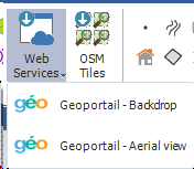
There are three backdrops:
•OpenStreetMap Tiles : These are tiles distributed by the WMTS OpenStreetMap server.
•Geoportail Backdrop : This is a backdrop hosted on the WMTS server of the IGN geoportal.
•Geoportail Aerial view : This is an aerial view hosted on the WMTS server of the IGN geoportal.
To add a backdrop, click on the corresponding button.
The backdrop layers are stored in the Backdrops group of the project layers list:

As this is data from the internet and updated in real time, access to this data depends on the state of the machine's internet connection.
A backdrop works in the form of a "tile", this means that each time you move in the graphics window, the canvas will update. This may cause latency depending on the quality of your connection. If its use is not desired, it is advisable to make it invisible.
This backdrop should always match the background. If you add a layer later, send to back the backdrop,so that it is covered by the other data.

Send backdrop to the back